Trail West Association Wildfire Protection
Plan
July 26, 2009
Trail West Village Association, Incorporated
Community Wildfire Protection Plan (CWPP)
Legal description and brief description of the Trail West
Association:
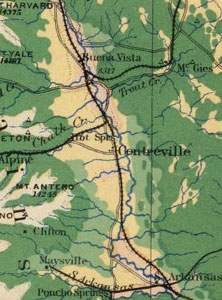
Trail West Development
Chaffee County, Colorado
Trail West Association, Inc.
-
The South half of the South half of Section 10, Township 14
South, Range 79 West of the 6th Principal Meridian; and
-
The Northeast quarter of the Southeast quarter of Section 9,
Township 14 South, Range 79 West of the 6th Principal Meridian,
and
-
Beginning at the South sixteenth corner
between Section 9 and Section 10, Township 14 South, Range
79 West of the 6th Principal Meridian being marked by a 1” aluminum
cap stamped LS 1776; thence North 01 16’09” East
along the West line of said section 10, a distance of 325.00
feet; thence South 85 14’35” East, a distance 1342.55
feet, more or less, to the East line of said Northwest quarter
of the Southwest quarter of Section 10; thence South 00
07’10” East
along said East line of the Northwest quarter of the Southwest
quarter of Section 10, a distance of 200.00 feet, more or less,
to the Southwest sixteenth corner of said Section 10; thence
South 89 25’15” West along the South line of said
Northwest quarter of the Southwest quarter of Section 10, a
distance of 1345.43 feet, more or less, to the true point of
beginning; containing 8.09 acres, more or less; and
- The Oglesby Tract, that tract of
land whose corners are marked with 5/8 inch steel reinforcing
bars, comprising all that southerly part of the Northwest quarter
of the Southeast quarter of Section 10, township 14 South,
Range 79 West of the 6th Principal Meridian, described as follows:
Beginning
at the Southeasterly corner of said subdivision whence the
Southeast corner of said section bears South 44º15’ East
1851.2 feet; thence North 1º 06’ East along the East
boundary of said Northwest ¼ of the Southeast ¼ a
distance of 250.0 feet; thence North 69º 34’ West 1392.2
feet to a point in the West boundary of said Northwest ¼ of
the Southeast ¼; thence South 1º12’ West 750
feet to the Southwest corner of said subdivision; thence North
89º24’ East 1315.6 feet to the point of beginning;
containing 15.09 acres.
Save and Except:
That certain 2.87 acre tract described in that certain Warranty
Deed, dated February 18, 1969, by Trail West Association, Inc.,
a Colorado Corporation, to the Young Life Campaign (now known
as Young Life), and recorded in Book 365, Page 92 of the Chaffee
County Clerk and Recorder’s office.
TWA currently includes 104 homes on 224 acres. Approximately
50% of the homes are occupied on a full time basis. The TWA has
an elected Board of Directors and established by-laws, restrictive
and protective covenants, and annual facility assessments. Board-appointed
committees include those that supervise Block Captains, Fire & Safety,
Forestry, Water, Roads, Architecture, the Monte Escondido Sewer
District, and interaction with Young Life. The TWA Property Manager,
Marvin Cordova, is responsible for maintaining TWA roads and facilities.
Community Wildfire Protection Plan
The following plan has been created for the proactive operations,
protection and safety of both the individual members and the
greater TWA community.
General Purpose:
- To extend the Chaffee County Community Wildfire Protection
Plan (CWPP) through an addendum specific to the goals and strategies
of the Trail West Association.
- To inform and support individual property owners through reduction
of wildfire risks and improvement of safe wildfire response through
a healthy forest.
- To create a coordinated TWA community plan for wildfire mitigation
and wildfire response.
- To develop a coordinated wildfire mitigation effort with Chaffee
County, the Colorado State Forest Service, the US Forest Service
(USFS), and adjacent private property owners.
- To seek and expand TWA resources and potential funding for
fuel reduction and TWA wildfire mitigation efforts.
Fuel reduction:
- To continue wildfire education of individual property owners
and encourage them to reduce on-site fuel throughout their property.
To develop safer, more defensible, perimeters around houses and
other structures. To get as many homeowners as possible
to sign on to mitigating their properties.
- To establish a committee to evaluate and rate each individual
property for fire hazards and notify the owners by mail of the
results. This report will include fire apparatus access to the
homes.
- To develop options and additional support for disposal of slash
either as bulk to landfill or chipping and disposal of chips.
- To request administrators of the USFS, Chaffee County, and
private property owners adjacent to TWA to improve wildfire mitigation
as well as fire suppression planning along TWA’s perimeter.
- To encourage the Colorado State Forest Service to up date the
Trail West Subdivision Hazard Rating Map of homes and properties
from the last one dated December 28, 1999.
Wildfire Response Preparedness:
- To research, evaluate, and potentially pursue additional options
for cistern water storage or dry hydrant installations. Currently
there is a dry hydrant located at 18850 Monte Escondido Drive,
a dry hydrant at the Young Life Trout Pond, and access to the
Young Life Lodge swimming pool and to the irrigation storage
facility just east of the south end of Camino del Norte and the
community bulletin board. There is also a small pond in
the Aspen Glen just west the TWA maintenance building. All
of the above are available for fire response.
- To negotiate with adjacent property owners, private and public,
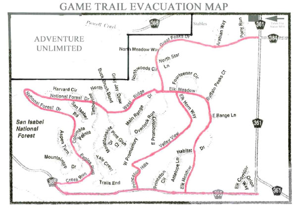
for emergency exit options in event of fire blockage of our single
entry/exit road. Trail West is in the unique position of also
having the Young Life Trail West Lodge adjacent to TWA property
and sharing the main interior roads.
The Young Life Lodge may have as many
as 200 people at the Lodge at one time and who, in the event of
a wild fire, would need to escape through Trail West Village. The
number of people trying to escape through the Village, especially
during the summer, could be doubled. This life-safety
issue needs to be seriously addressed! Currently
there are two emergency exits into the USFS/Red Deer area. The
USFS roads are poorly maintained, especially for emergency
use. They require 4X4, high clearance, vehicles (a safe speed is
only 5 miles per hour) and the USFS does not allow drive-through
practice. This is particularly dangerous since so many of
the TWA residents are elderly. One exit area is only a hundred
yards distance from the established 4X4 roads in the USFS area
that are used every hunting season. The other is about 300 yards
from the USFS road. A night time emergency could be catastrophic,
especially if the emergency exit reflective markers provided by
the TWA have been removed. This exit eventually leads to CR 340-A,
but has a steep tight curve around a quarry.
Young
Life has also provided an emergency exit that leads east from just
south of the bulletin board off the main TWA road across an irrigation
ditch to the lane just east of Trail West and then south to CR
340 B. TWA will work with Young Life to develop and coordinate
an emergency exit plan. The CCFPD will be asked to assist in mapping
out such a plan.
- To ask the CCFPD to evaluate Trail West roads for ease of accessibility
and to make recommendations for improvement of TWA roads.
- To revise the existing subdivision map with updated homeowner
status and phone numbers, including cell phone numbers, to allow
contact with residents during an emergency when residents are
at home or absent. To distribute this map to all local fire response
teams. It is currently provided to the CCFPD, the Chaffee
County Sheriff’s department, and the Colorado State Forest
Service, Salida District..
- To contact and discuss wildfire issues and protection with
TWA’s immediate private neighbors. To secure cooperation
in applying wildfire hazard reduction on these adjacent lands
and record neighbors’ contact information so that they
too can be informed of any fire emergencies.
- To designate specific TWA members (e.g. TWA Board members,
Block Captains, and/or a Wildfire Mitigation Workgroup) to be
responsible for informing other TWA residents of a local or approaching
fire, assisting with evacuation procedures and routes, and coordinating
information for incoming fire fighting teams.
- To develop and pursue grant applications that include specific
needs identified in the TWA Wildfire Protection Plan, including
fuel reduction and waste disposal. To designate an individual
who will be responsible for coordinating the development of grants.
- TWA would like to utilize the S-212 class at the Colorado Fire
Camp in Maysville, Colorado to do at least some of the work at
Trail West for in-kind services in our application for a grant.
Specific Objectives:
None of the objectives are to be construed as a requirement
on individual TWA property owners. Actions on individual properties
are the responsibility and at the discretion of each TWA member.
Education and Coordination to Date
- For at least the last 10 years TWA members have been told about
the wildfire dangers in Chaffee County and have been given emergency
procedures and exit map plans in the biennial TWA Directory.
All property owners receive a copy and the Fire & Safety
Chairman reviews the section at the TWA Annual Meeting. A
Block Captain Communication and Fire Response Committee has been
in place for this period of time. TWA members have also been
given FireWise information for reducing fuel and other obstacles
on their individual properties. (See copy of the “Trail
West Directory” for Emergency Procedures and FireWise information). Emergency
procedures will be updated for the 2011 Directory.
- Property owners continue to reduce fuel hazards on their individual
properties in 2009.
- For a number of years the TWA Forestry Committee has worked
to cut dead trees in the Aspen Glen and in the common areas to
thin dead and dying fuels.
- March 5, 2009. Lyn Tucker, TWA Chairman; Kent Bickel,
TWA Forestry Committee Chairman; and Suzanne Paddock, TWA Fire
and Safety Committee Chairman attended the CWPP public awareness
meeting conducted by Chaffee County and the USFS in Buena Vista,
Colorado. At the following TWA Board meeting, it was decided
that TWA would get on board with the CWPP. [2 hours]
- June 18, 2009. The above named people attended a meeting
with Mark Thomas, Mitigation Coordinator for Chaffee County Fire
Protection District, to learn further steps in designing and
planning a CWPP addendum for Trail West Village. [2 hours]
- June 8, 2009. Suzanne Paddock and Sonya Griffith met to formulate
the TWA plan. [2 hours].
- June 24, 2009. The same TWA Committee met, with the addition
of David Aldrich, Bruce Clardy, and Sonya Griffith. [1½ hours]
- July 6, 2009. Five committee members met to refine the
CWPP. [1½ hours].
- July 11, 2009. Mark Thomas, Mitigation Coordinator from
Chaffee County Fire Protection District, and State Forester Damon
Lange addressed the TWA community at their annual meeting to
discuss the CWPP. Ten residents responded to the offer to discuss,
on-site, fire hazards on their individual properties.
- July 26, 2009. Meeting of Committee to review grant application
submission to Colorado Forest Service, and CWPP. [1hour]
- August 4. 2009. TWA Board of Directors approval of the
CWPP document.
|